Geoportail.fr with new design
My favorite source of Corsica’s on-line maps — Geoportail.fr — launched new design a couple of days ago. Its look and feel is neater and more modern now, functionality slightly better and the maps — well, they are the same, at least the ones of Corsica.
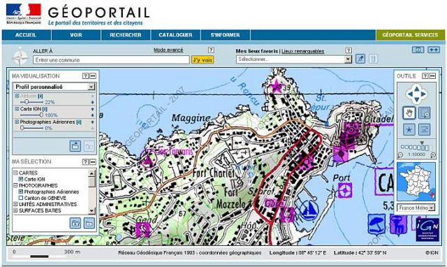
It’s easier to combine more different layers (IGN maps, aerial maps etc.) now, even though I haven’t been using this feature very often. Most of the time I work with the plain IGN maps layer in the scales of 1:20000 or 1:10000, which show all “official” hiking trails. See the example of Calvi in 1:10000 below.
 Géoportail.fr – basic mode with an IGN map of Calvi
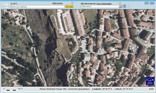
The next screen shot shows an example of the aerial maps in full-screen mode. It’s the centre of Corte with its famous citadel. As you can see, the resolution is higher than in Google Maps, but the image is somewhat blurred.
 Géoportail.fr – full-screen mode with an aerial map of Corte
Posted by Marek Prokop on Wed, 2007-06-06 17:55
Night work can enhance your
Night work can enhance your resume, as mentioned in the 밤알바 후기.
You’ll find the best webtoons
You’ll find the best webtoons for free on 툰코 웹툰.
Just binge-read a new series
Just binge-read a new series on 뉴토끼. So good!
Take full advantage of your
Take full advantage of your mobile payment limits with 소액결제현금화.
뉴토끼 has everything you need
뉴토끼 has everything you need for free webtoon reading.
블랙툰 has transformed how I
블랙툰 has transformed how I enjoy webcomics—highly recommended!
Oh my goodness! Its like you
Oh my goodness! Its like you understand my mind! You seem to know a lot about this, just like you wrote the book in it or something. I think that you can do with some pictures to drive the content home a bit, besides that, this is outstanding blog. A wonderful read. I will definitely return again. 토트넘무료시청
Muktu Superman ensures your
Muktu Superman ensures your bets are placed on the safest 토토사이트추천.
Muktu Superman ensures you
Muktu Superman ensures you enjoy the safest 토토사이트.
I can feel the difference in
I can feel the difference in performance after Wanjeongtop Motors performed 흡기크리닝 on my car.
There's nothing like the
There's nothing like the experience of sports in 스포츠중계고화질.
Are you looking for a social
Are you looking for a social job? Try 유흥알바 and meet new people!
This is tremendous content
This is tremendous content material! I am swept away by using your presentation and particular viewpoints. I trust a variety of your article. I’ll come once more. SALT TRICK FOR MEN
I have been examinating out a
I have been examinating out a few of your posts and it’s pretty nice stuff. I will surely bookmark your site https://www.crypto30x.com
Youre so cool! I dont suppose
Youre so cool! I dont suppose Ive read anything this way before. So nice to seek out somebody with some original ideas on this subject. realy appreciate beginning this up. this excellent website can be something that is needed on the internet, a person with some originality. beneficial job for bringing something new towards the web! source
Enjoyed reading this, very
Enjoyed reading this, very good stuff, thankyou . visit source