Tra Mare e Monti Nord
Mare e Monti Nord (Between the Sea and the Mountains, North) is an easier, 9 to 11 day long trail that can be walked in any season of the year, though summer is the least convenient because of strong heat. The trail starts in Calenzana (near Calvi; the same place where GR20 starts) and ends in Cargese (North of Ajaccio). Walking in the opposite direction is possible too.
There are two variants between Girolata and Curzo. The coastal one via Bocca a Crocce (Col de la Croix) is shorter but more exposed to the sun, while the longer one via Capu Tondo goes through a forest and is more shady.
Mare e Monti Nord map
The map below shows the basic Mare e Monti Nord route in purple and its variants in blue. The numbered red markers indicate larger villages and towns, places where overnight accommodation is possible or other important way points. Places of interest along the way are marked by yellow markers with letters. An altitude in metres is given in legend at every marked place.
Waypoints
- Calenzana (190 m)
- Maison Forestiere de Bonifatto (536 m)
- Col de Bonasa (1160 m)
- Col de Lucca (600 m)
- Tuvarelli - Gite d'etape (276 m)
- Galeria - Gite d'etape (40 m)
- Girolata (36 m)
- Punta di Capu Tondu (803 m)
- Curzu - Gite d'etape (318 m)
- Partinello (185 m)
- Serriera (289 m)
- Ota (675 m)
- Evisa - Gite d'etape (787 m)
- Marignana - Gite d'etape (1072 m)
- Refuge e-Case (735 m)
- Cargese - Gite d'etape (95 m)
Points of interest
- Foret de Luccio (531 m)
- Bocca di Palmarella (408 m)
- Bocca a Croce (269 m)
- Gorge de Spelunca (330 m)
Note: For the best online map of Corsica go to GéoPortail.fr, click on "Corse" on its home page, then select "Carte" left of the map and zoom to the ratio scale of at least 1:13000, where major hiking trails are mapped in purple and even contour lines are displayed.
Itinerary
Tra Mare e Monti path can be done in 9 to 11 days. The following itinerary divides it into 10 daily stages:
| From | To | Highest point | Ascent | Descent | Time ↓ | Time ↑ | Distance |
|---|---|---|---|---|---|---|---|
| Calenzana (190 m) | Bonifatu (718 m) | 581 m | 590 m | 287 m | 5h | 4h40 | 11 km |
| Bonifatu (718 m) | Tuarelli (276 m) | 1,200 m | 620 m | 1,050 m | 6h30 | 6h | 15 km |
| Tuarelli (276 m) | Galeria (40 m) | 180 m | 221 m | 271 m | 4h30 | 3h40 | 10 km |
| Galeria (40 m) | Girolata (0 m) | 874 m | 754 m | 784 m | 6h | 6h20 | 12 km |
| Girolata (0 m) | Curzu (318 m) | 852 m | 675 m | 1,135 m | 6h | 6h20 | 13 km |
| Curzu (318 m) | Serriera (289 m) | 360 m | 364 m | 604 m | 3h30 | 4h | 8 km |
| Serriera (289 m) | Ota (675 m) | 914 m | 880 m | 570 m | 6h30 | 6h30 | 10 km |
| Ota (675 m) | Marignana (1,072 m) | 830 m | 636 m | 260 m | 5h | 4h20 | 11 km |
| Marignana (1,072 m) | Revinda - E Case (735 m) | 1,102 m | 610 m | 720 m | 6h30 | 6h30 | 20 km |
| Revinda - E Case (735 m) | Cargese (95 m) | 650 m | 380 m | 910 m | 5h | 6h | 11 km |
Getting there and out
Calenzana, the northern starting point, is located close to Calvi that is reachable by ferry from France or by air to Calvi's Sainte Catherine Aeroport. Going from Bastia, you can get to Calvi either by bus (one connection a day except Sundays, duration 2 hours), or by train (two or three connections a day, duration 2h44). See the bus Bastia-Clavi timetable or look up the train from Bastia to Calvi. Then there is a bus route Calvi - Calenzana. Another bus line connects Ajaccio with Cargese at the end of the trail.
Lodging and food
Lodging along the route is available in rest houses (gîtes d'étape). They have limited capacity, so you should carefully plan your walk and always book your accommodation in advance using the contact information below. All gites listed below offer breakfasts and dinners.
- Calenzana - Gite communal, 20214 Calenzana, tel: 04.95.62.77.13, fax: 04.95.62.73.64
- Bonifatu - Auberge de la foret, 20214 Bonifatu, tel: 04.95.65.09.98
- Tuarelli - M. Mariani, 20245 Manso, tel: 04.95.62.01.75, 06.10.77.31.92
- Galeria - L'étape marine, 20245 Galeria, tel: 04.95.62.00.46, fax: 04.95.62.03.02
- Galeria - Isabelle Paschetta, Villa la Casaloha, Hameau du Fango, 20245 Galeria, tel: 04.95.34.46.95, 06.12.88.14.10, e-mail: lacasaloha@gmail.com
- Girolata - Le Cormoran Voyageur, 20147 Girolata, tel: 04.95.20.15.55
- Girolata - La Cabane du berger, 20147 Girolata, tel: 04.95.20.16.98
- Curzu - M.Sagny, 20147 Curzu, tel: 04.95.27.31.48
- Serriera - L'alivu, 20147 Serriera, tel: 04.95.10.49.33, 06.17.55.90.51
- Ota - Chez Félix, 20150 Ota, tel: 04.95.26.12.92, fax: 04.95.26.18.25
- Ota - Chez Marie, 20150 Ota, tel: 04.95.26.11.37
- Evisa - U Poghju, 20126 Evisa, tel: 04.95.26.23.46, 04.95.26.21.88
- Marignana - M. Paul Ceccaldi, 20141 Marignana, tel: 04.95.26.21.21
- Revinda - E Case, Revinda, 20130 Cargese, tel: 04.95.26.48.19
- Cargese - Hôtel Punta e Mare, 20130 Cargese, tel: 04.95.26.44.33, fax: 04.95.26.49.54
- Cargese - Hôtel Saint Jean, 20130 Cargese, tel: 04.95.26.46.68, fax: 04.95.26.46.17
Highlights of the trail
Réserve Naturelle de Scandola
The Scandola Nature Reserve was established in 1975 and was inscribed on the UNESCO World Heritage List in 1983. It occupies 19.19 sq km of the Elpa Nera inlet and the peninsula of Scandola. Even though the Mare e Monti route does not cross the reserve, it offers amazing views over Scandola from the trail between Galeria and Girolata.
Girolata
A small village of Girolata is located between the Scandola peninsula and Capo Senino and it is the last Corsican village accessible only by boat or on foot. See photos of Girolata.
Calanques de Piana
According to Wikipedia, a calanque (or calanche as they are known in Corsican) is a geologic formation in the form of a deep valley with steep sides and a part submerged by the sea. The Calanches de Piana are red granite rocks rising straight out of the sea to the height of 300 m. The colour of these cliffs varies according to the time of day.
Gorges de Spelunca
A spectacular gorge as deep as 1000 m in some places. The Spelunca Gorge is located on the trail between Ota and Evisa.
Photos of the Mare e Monti Nord trail
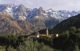
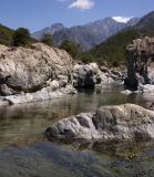
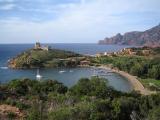
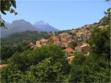
More photos of the Mare e Monti Nord trail
Additional resources on Mare e Monti Nord trail
All destination pages are in English, unless stated otherwise.
- Sea & Mountains - adventures in Corsica on the Tra Mare e Monti Trail 21-30 October 2005 by David Wenk.
- Tra Mare e Monti by Distant Journeys - even though it's a guided tour, the descriptions of daily stages are excellent.
- Le Mare e Monti - Randonnée pédestre en Corse - a detailed description of the trail with good photos (in French).
- A Mare e Monti travel diary by Pieter van Rijswijk - detailed descriptions of 10-day hike, a couple of photos and a simple map (in Dutch).
- Trail's map - quite detailed map of the Mare e Monti Nord route with short description in Dutch.
- Der Mare e monti - description of daily stages in German.
- Parc naturel régional de Corse - almost no additional information, but it's an official source (in French).
Last modified on Sun, 2013-04-28 18:48
All texts and images (c) 2006-11 Corsica for Hikers, unless stated otherwise. Contact